SINGAPORE: To manage crowds at this year’s countdown celebrations, the Singapore Police Force (SPF) will be releasing real-time photos of the situation at Marina Bay and Kallang.
Police are expecting “very large crowds” at both locations and may also close certain areas if they become overcrowded.
People who are planning to head down are advised to check the crowd levels on the Crowd@MarinaBay and Crowd@Kallang websites.
Besides showing real-time crowd levels and area closures, it will also have photos of each site. These photos will be updated “periodically”, said the police, although they did not specify how often the photos would be refreshed.
Users can view the photos by clicking on the camera icon on the maps.
The websites will be available on mobile phones from 7pm on Dec 31 for Marina Bay, and from 8.30pm for Kallang Basin.
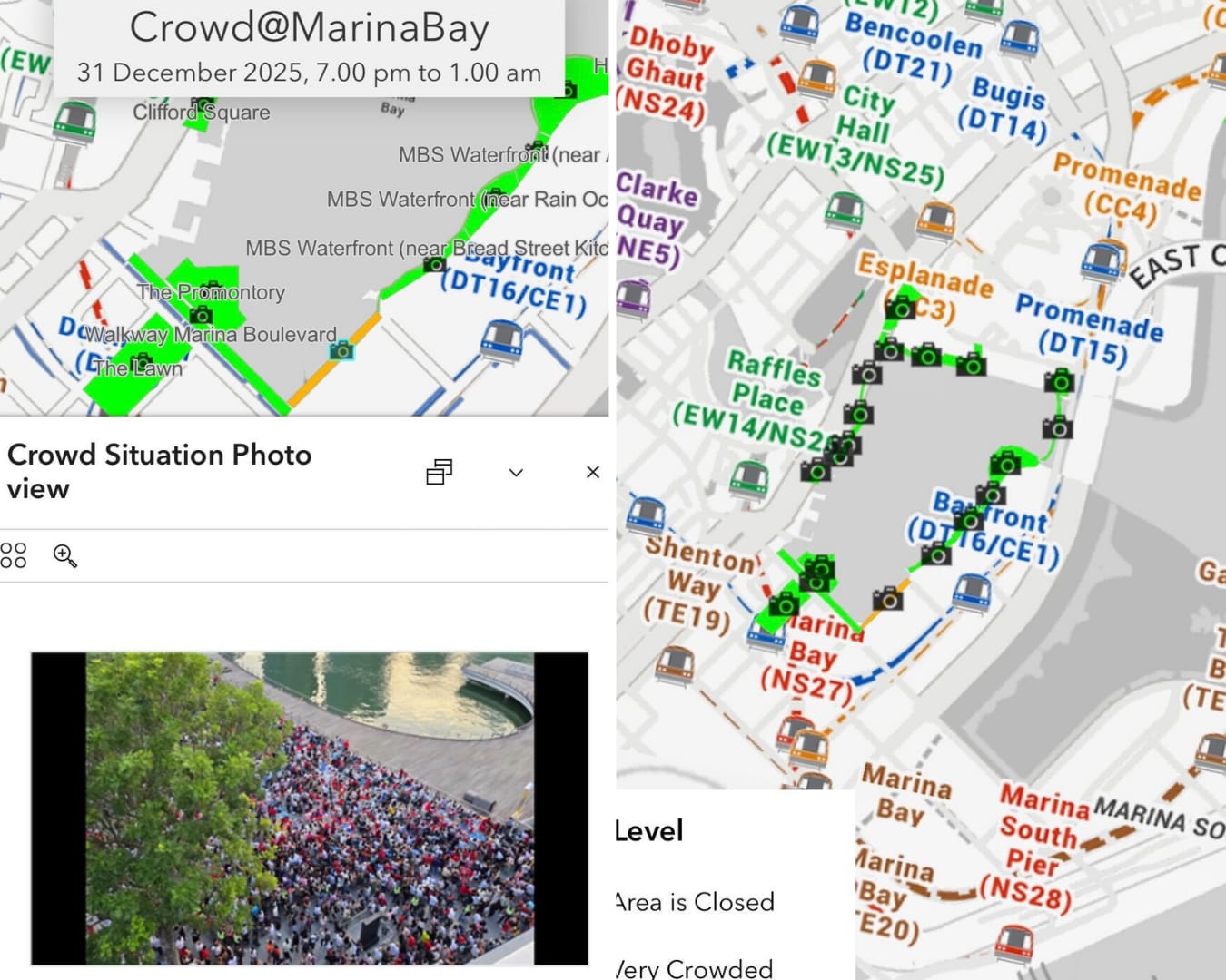 An example of what photos of the crowd would look like on the Crowd@MarinaBay portal. (Screenshots: CNA/Natasha Ganesan)
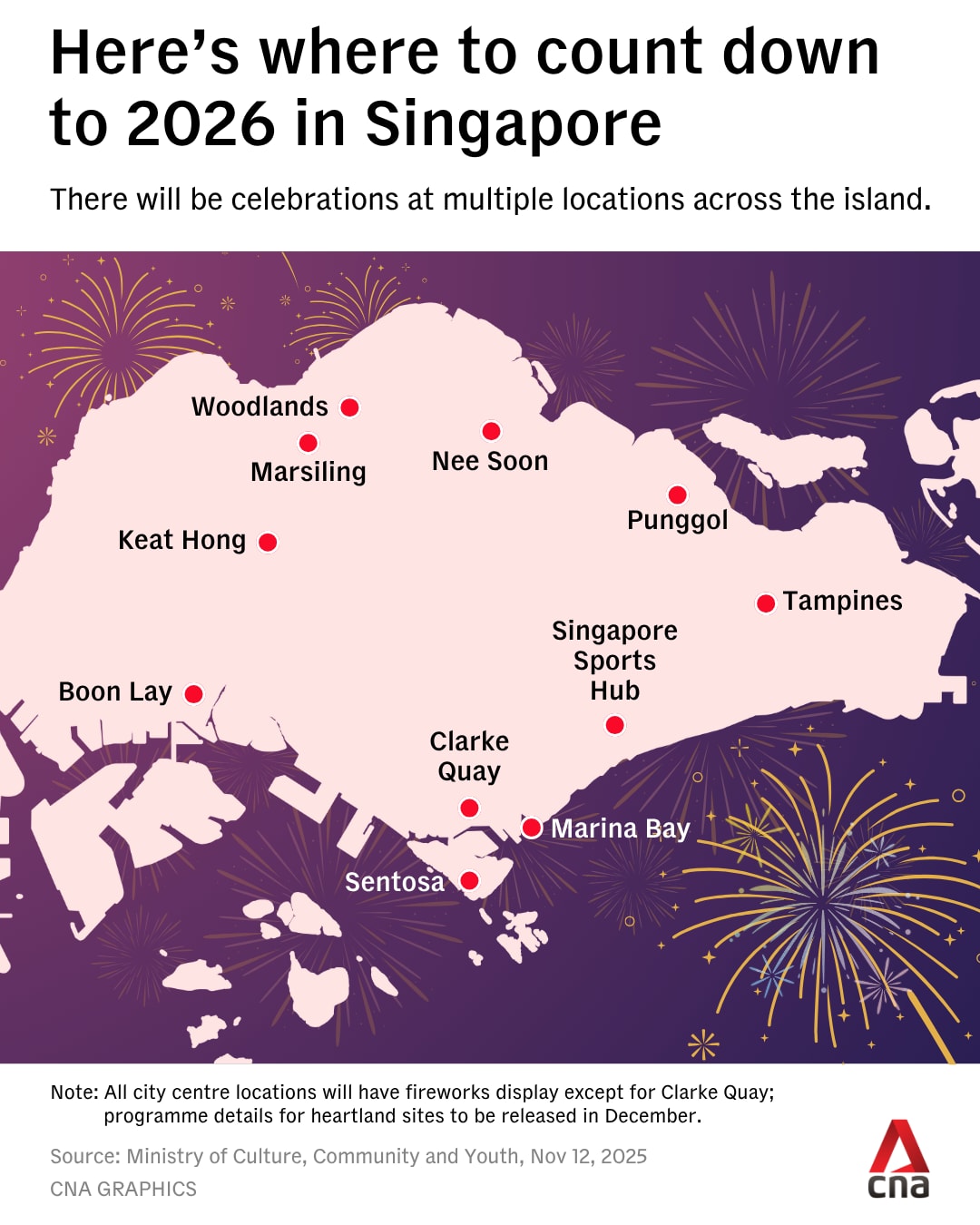
Apart from Marina Bay and Kallang, various activities are also lined up at Sentosa and Clarke Quay, as well as seven heartland sites.
Police and other security officers will be deployed to ensure the safety and security of the public, as well as to manage crowds, said SPF in a news release on Sunday.
There may also be checks on members of the public, including their bags and personal items.
People are advised not to cycle around Marina Bay and the Kallang Basin, as the area will be congested and the risk of injuries during a collision is high.
“Members of the public are reminded not to engage in activities that may compromise the safety of others,” said SPF.
“The police will not hesitate to take action against anyone who causes public nuisance, acts rashly or breaks the law.”
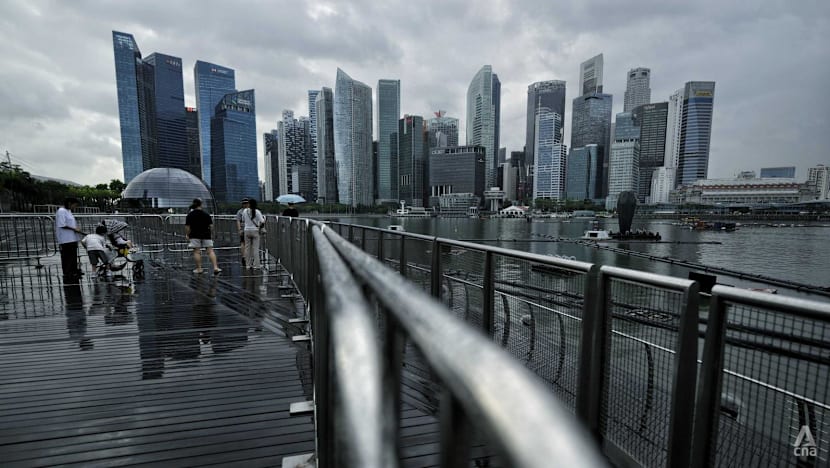
 Officers from the Emergency Response Team patrolling the area around Marina Bay on Dec 29, 2025, ahead of the countdown event. (Photo: CNA/Wallace Woon)
CROWD MEASURES
To prevent overcrowding, authorities will regulate the number of people entering The Promontory, One Fullerton, Merlion Park, Esplanade Park, Esplanade Waterfront Promenade, Marina Bay Sands Waterfront Promenade, and other areas at Marina Bay.
Similar crowd control measures will be implemented at Stadium Roar, Stadium Riverside Walk, Beach Volleyball Court, Lawn Bowl, Tanjong Rhu Promenade and Water Sports Centre at the Kallang Basin.
When crowd levels reach safety thresholds, they will be closed to ensure public safety, said the police.
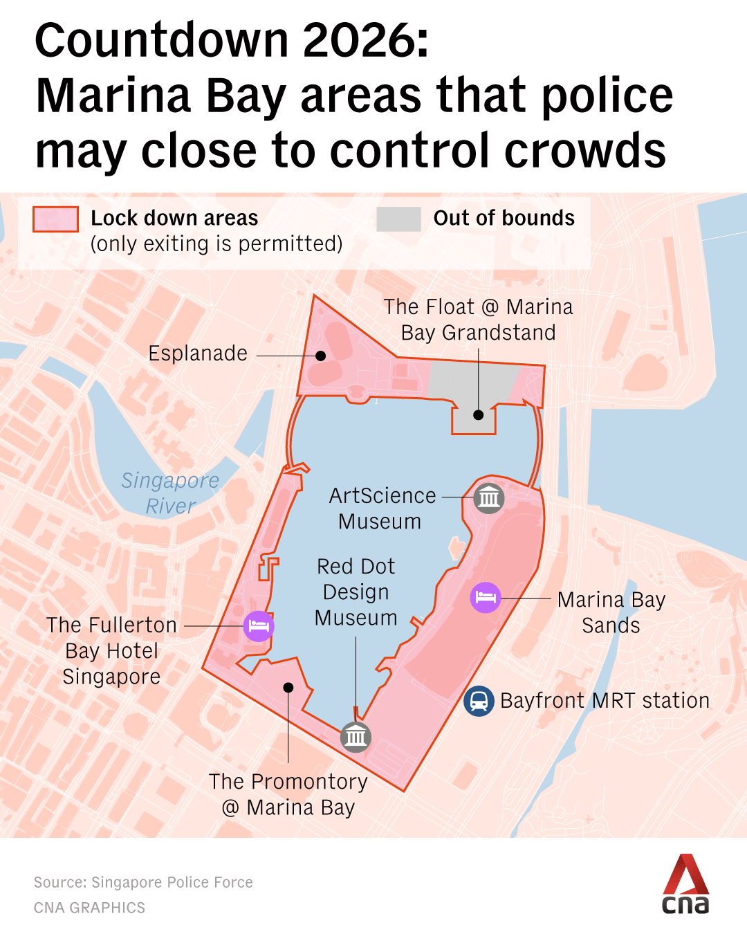
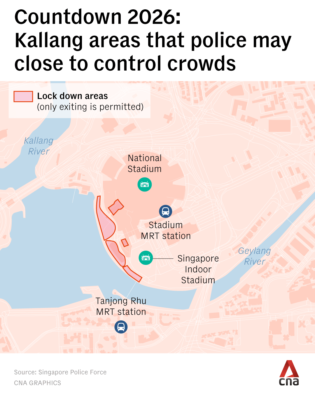
Some entrances and exits of MRT stations around Marina Bay and Kallang Basin will be closed to regulate crowd flow.
In the event of overcrowding, trains may bypass stations such as Bayfront and Stadium MRT stations to divert crowds away from these affected areas.
"Members of the public are advised to be patient and to follow the instructions of security personnel on duty," the police said.
MRT stations, including City Hall, Raffles Place, Bayfront, Stadium, Tanjong Rhu and Nicoll Highway stations, are expected to be very crowded.
People are encouraged to use nearby alternatives such as Esplanade, Promenade, Downtown, Marina Bay, Kallang and Mountbatten MRT stations.
“The footways along the Esplanade Bridge, Bayfront Avenue, Merdeka Bridge and Tanjong Rhu Bridge are for transit purposes only,” said the police.
“Pedestrians will not be allowed to stop and congregate on these footways.”
 Barricades set up around the Marina Bay Sands boardwalk on Dec 29, 2025, as part of crowd control measures ahead of the countdown event. (Photo: CNA/Wallace Woon)
PUBLIC TRANSPORT SERVICES
There will also be a “significant extension” of public transport service hours to accommodate the activities.
Train services on SMRT’s North-South, East-West, Circle and Thomson-East Coast lines will be extended, with the last trains departing between 1.38am and 2.15am.
Trains on SBS Transit’s Downtown and North East lines, as well as on the Sengkang-Punggol LRT system, will be extended by about two hours and 15 minutes.
"There will not be a need to rush after midnight to catch the last trains," the police said.
"After the event, dispersal is likely to be slow and will take considerable time due to the large crowds. There will be designated routes out of Marina Bay and Kallang Basin to facilitate safe and orderly dispersal."
Signs will be put up to guide people on the routes for dispersal. These include six new digital animated signboards placed around Marina Bay to provide information such as alternate MRT routes and last train timings.
Crowd flow into the train stations will also be regulated, and commuters may be directed to other MRT stations nearby to avoid overcrowding.
"We seek your understanding to head to these less-crowded MRT stations and use the interconnected MRT networks to get to your intended destination," said the police.
"Alternatively, you can head to the other islandwide festivities, including those at the heartlands, for a more convenient and fuss-free journey," they added.
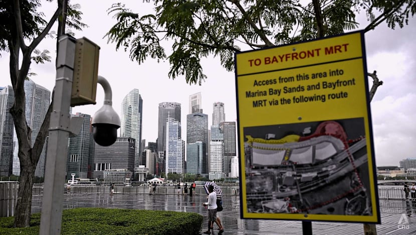 A CCTV camera and sign set up around the Marina Bay Sands boardwalk on Dec 29, 2025, as part of crowd control measures ahead of the countdown event. (Photo: CNA/Wallace Woon)
TRAFFIC ADVISORY
A number of roads and lanes will also be closed to all vehicles during the celebrations.
The open space car park along Bayfront Avenue will also be closed. The public is advised to take public transport to Marina Bay due to limited parking spaces in the area.
Vehicles parked in buildings located within the closed roads may not be able to exit during the road closure periods.
Signs will be put up near affected roads, and auxiliary police officers will be deployed to regulate traffic and assist motorists.
For public safety, the police will close one carriageway of Sheares Avenue towards Marina Bay Sands from 11.30pm on Dec 31 to 12.15am on Jan 1.
Motorists can access Marina Bay Sands via the Marina Coastal Expressway-Ayer Rajah Expressway route instead.
Parking along peripheral roads and stopping on the Benjamin Sheares Bridge to watch the fireworks are strictly prohibited. Enforcement action will be taken against errant motorists, with obstructing vehicles towed away, said the police.
Closed roads and lanes
Dec 31, 6pm to 9pm
- The left lane of Fullerton Road in the direction of Collyer Quay (between Esplanade Drive and Collyer Quay)
- The left lane of Collyer Quay in the direction of Raffles Quay (between Fullerton Road and Raffles Quay)
- The right lane of Esplanade Drive in the direction of Nicoll Highway (between Fullerton Road and Stamford Road)
Dec 31, 6pm to Jan 1, 2am
- Bayfront Avenue (between Temasek Avenue and lamp post 34F)
- The slip road leading from Bayfront Avenue into Raffles Avenue
- Esplanade Drive in the direction of Fullerton Road (between Nicoll Highway and Fullerton Road)
- The slip road leading from Raffles Avenue into Esplanade Drive
- Fullerton Road (between Esplanade Drive and lamp post 18)
Dec 31, 9pm to 11pm
- The extreme right lane of Collyer Quay in the direction of Fullerton Road (between Finlayson Green and Fullerton Square)
Dec 31, 9pm to Jan 1, 2am
- Fullerton Road in the direction of Esplanade Drive (between Collyer Quay and Esplanade Drive)
- Fullerton Road in the direction of Collyer Quay (between Esplanade Drive and Collyer Quay)
- Collyer Quay in the direction of Raffles Quay (between Fullerton Road and Raffles Quay)
- Esplanade Drive in the direction of Nicoll Highway (between Fullerton Road and Stamford Road)
Dec 31, 10pm to Jan 1, 2am
- The left two lanes of Finlayson Green in the direction of Marina Boulevard (between Robinson Road and Raffles Quay)
- Marina Boulevard (between Collyer Quay and Bayfront Avenue)
- Bayfront Link (between Bayfront Avenue and lamp post 10F)
- Raffles Avenue (between Bayfront Avenue and Esplanade Drive)
- Temasek Avenue in the direction of Bayfront Avenue (between Raffles Boulevard and Raffles Avenue)
- Nicoll Highway in the direction of Guillemard Road (between Stamford Road and Bras Basah Road)
Dec 31, 11pm to Jan 1, 2am
- Collyer Quay in the direction of Fullerton Road (between Finlayson Green and Fullerton Square)
- Fullerton Square in the direction of Battery Road (between Collyer Quay and lamp post 1)
- Nicoll Highway in the direction of Esplanade Drive (between Bras Basah Road and Stamford Road)
- The slip road leading from Raffles Boulevard into Temasek Avenue
- Temasek Avenue in the direction of Temasek Boulevard (between Raffles Avenue and Raffles Boulevard)
- Raffles Boulevard in the direction of Raffles Avenue (between lamp post 23F and Raffles Avenue)
- Raffles Avenue (between Republic Boulevard and Temasek Avenue)
- Republic Boulevard in the direction of Raffles Avenue (between Republic Avenue and Raffles Avenue)
Dec 31, 11.30pm to Jan 1, 12.15am
- The right lane of Republic Boulevard in the direction of Ophir Road (between Republic Boulevard and Ophir Road)
- The slip road leading from Ophir Road into Sheares Avenue
- East Coast Parkway in the direction of Sheares Avenue (between Exit 14 and Sheares Avenue)
- The slip road leading from Kallang-Paya Lebar Expressway into East Coast Parkway (Sheares Avenue)
- Sheares Avenue in the direction of Central Boulevard (between East Coast Parkway and Sheares Link)
- The slip road leading from East Coast Parkway (Sheares Avenue) into Rochor Road
Dec 31, 11.30pm to Jan 1, 2am
- Sheares Link in the direction of Bayfront Avenue (between Sheares Avenue and Bayfront Avenue)
Collapse Expand
The Civil Aviation Authority of Singapore will establish temporary restricted areas from 7pm at Marina Bay and 8.30pm at the Kallang on Dec 31 until 1am on Jan 1.
During this period, all aerial activities, including flying kites or drones and hoisting captive balloons, are prohibited.
 (Graphic: Nurjannah Suhaimi)